the UN, fighting the important fights /s
The Mercator map, which has been in common use since the 16th Century, has come in for criticism as it shows Africa as similar in size to Greenland, even though it is 14 times larger.
Critics say this leads to the development needs and potential for countries near the equator to be minimised.I think that’s got more to do with the systemic legacy of colonialism than with which world maps people look at.
No corresponding maximization of development needs and potential for Greenland either.
The Mercator projection is also a systemic legacy of colonialism, so doing away with it doesn’t hurt.
Mercator projection was favoured because it was useful for navigation due to preserving rhumb lines, representing them as straight lines on the map, and has been around for like 400 years.
Given that barely anyone does navigation like this any more it’s not that important to keep it as the default view for world maps that aren’t used for navigation such as a simple wall map. Web maps and the use of pseudomercator have definitely kept it relevant in modern times and as the most recognizable projection.
There isn’t much basis to say it’s used to “make colonial countries look bigger and Africa look smaller” except for people virtue signaling in blog posts over the last decade. If anything then it’s a psyop by Big Greenland.
As this post explains, you can just look at a globe if you want accurate size representation, because all map projections are distorted and there is always a tradeoff.
E: Oops I can see several people already explained this since refreshing the post.
it’s used to “make colonial countries look bigger and Africa look smaller”
I dont disagree, but I think if the case was opposite and a useful projection made the countries in power look smaller they wouldn’t have picked it as their favourite projection. The distortion is in favour of the (small) powerful countries, which may not have been the main reason but you can’t call it a happy coincidence either.
This may or may not be true—in fact I’ll just assume that it’s true, fuck it—but I will say that it’s kind of like being asked to have an opinion on whether this person or that gets top billing on the theater marquee: is it going to be Rose & Krants or Krants & Rose? Which do you think, morally, is the superior option? I really, really don’t care.
And it bothers me a smidge that people do only because I feel like they’re being distracted by jangling keys. But oh well, whatever. Not my business, I guess.
I, for one, thought Africa had a smaller footprint that it has because of the maps in school and it made me think that it was less signifiant than it is. It doesn’t make sense, because a country could be very little but have billions of people in it for example. Nonetheless, I get the feeling. If I was from a country that suffered from colonialism and whatnot, I’d want a better projection of it on 2d maps. Simply because I know a chunk of people would better see my nation’s place in the world.
A country’s, or a continent’s, signifigance has nothing to do with it’s size, though.
I mean, if we wanted to make the nations of Africa or Greenland feel better, does it follow that we could make them appear bigger on the map than they actually are? Just move the mercator around such that Africa is along the top or bottom edge of the map where things are larger?
I am absolutely not saying that people having a better understanding of Africa is bad. I just don’t think that this is really how that happens.
I remember thinking that Russia seemed pretty big on the map, and yet still, I’ve never had to take Russian culture as a class in high school.
[edit] I’ll add one thing, though. This decision has clearly pissed the US government off, which is based and incredibly funny. I’ll support it to that end.
Depends what type of significance. Of course it’s more significant when it’s larger in size if you value things like farmland, natural resources, fishing, transportation, infrastructure, timezones, language, etc.
If you think the US is similar in size to Africa, like I thought, and you compare the 51 states to the 54 countries, you might think each African country is similar in area to a state in the USA and extrapolate to other beliefs accordingly. Maybe you think there is a greater cultural cohesion in the entire continent because people are closer to each other and so on. Turns out, there is more than 1.5 billion people in Africa. That is way more than in the US, but the size is really skewed in the Mercator.
I don’t understand your point about wanting to make Greenland feel better. The Equal Earth Projection is more accurate when looking at land area, so it’s not a question of making people feel better about the size of their country, more of a question of not having the Mercator projection contributing to people thinking less of our country, amongst other things, like just being more factual.
And like the other commenter said, Russia doesn’t really have this problem anyway, it’s very large in all our popular projections.
It is a coincidence though, in the sense that the Mercator projection by necessity inflates things near the poles relative to the equator.
The major powers at the time were countries like Britain, Spain, France, and Italy. Not Norway, Sweden, Finland, Russia, and Canada, which are inflated far more than the former.
The countries in power didn’t change much in size, but the countries they controlled did. I stand by my point, if this was the other way around and a useful projections shrank everything near the poles (and Africa looked much bigger on the map than it already is), those people would likely dislike that projection. They would ask themselves why it was so skewed, while now it was no issue. It is a coincidence that Mercator works that way, but it is no coincidence they liked this one so much.
Saying it was just handy is downplaying the strong sides of other projections. Take a look at maps from that period and see how many inaccuracies there are, because they had no satalite to check how right they were. Navigators weren’t stupid and they would easily understand how to navigate another projection if Mercator was disregarded for some reason.
Take a look at historic uniforms, the amount of jewelry etc; people have been vain since the beginning of time and have always cared about the looks of it. I honestly can’t imagine they would have been fine with a map were they seemed smaller than they actually were, i can easily imagine they would be glad to use a map that showed them bigger then they are.
The countries in power didn’t change much in size, but the countries they controlled did.
Sorry, but this is just a strange thing to say. The size of any place on a map can only be measured relative to other places on the map. “The countries in power didn’t change much in size” just doesn’t make any sense.
At the time when the Mercator projection was invented, we already had plenty of maps that gave a more accurate picture of the size of different land masses. The countries in power were actively colonising a lot of the world, so you better bet they would want to amplify their achievements.
The Mercator projection wasn’t “just handy”. It was literally the first widely used map projection that lat people sail across open seas and get where they wanted. That’s a life/death matter. It’s literally an integral part of the power of navigating the world seas.
The fact that it compresses the equator is directly a result of where the magnetic poles of the earth are aligned relative to the geography of the continents.
Every map projection has some inaccuracies and thing that they’re good and bad at. The Mercator is good at preserving shape and distance, which used to be quite important for navigating around the world, which was important for colonization. Other maps have accurate size but inaccurate shapes. The Mercator projection isn’t the worst, but less suited for the needs of today. We should all probably just use globes. The UN should also use globes.
Good luck keeping a globe in the glove box.
Just gotta inflate it…

You still use paper maps while driving inside of your own country? Free navigation software is ubiquitous. Noone cares about the projection used there, as long as it signals turns and lanes correctly, and long distance most countries have something called “signs” which tell you where the road you are on goes.
Imagine ridiculing the skill of reading a map instead of offloading your entire cognitive self to a phone app.
Imagine being proud of skills which have become obsolete in the last century for the vast majority of uses. Reminds me of the people whining about the loss of cursive writing skills, and cursive at least makes writing long texts more hand-friendly. I can read and use maps (if i ever again wanted to) but they neither update, don’t fit neatly in my pocket, suffer from wear and tear (funnily enough they suffer from water damage a lot more than my smart phone, which i forgot i had in my swimwear - i was around 1 1/2 hours in the water, and after blowing some air in the USB-C port, everything was still working. Try that with a paper map, i dare you), don’t deliver context or images of the surroundings, do not have turn or lane info, completely miss important data like construction work or road blockages and are unable to provide you with traffic data.
Even for non-navigation stuff paper maps are wildly unpractical compared to the digital alternative. City planning, construction work and the likes all need easily updateable, versionable maps that do not distort the size of things like mercator.
Imagine starting arguing over a joke.
The Mercator projection is a legacy of people needing a world map in which local regions preserve accurate directions and proportional distances (i.e., people who need a map for navigation instead of a global dick-measuring contest).
In the times of GPS, global navigation isn’t reliant on this specific map projection. On a local level (City or State/Province level), where most navigation for non-experts is taking place, the chosen map projection doesn’t matter that much. The people who are navigating distances where these things become relevant (pilots and ship navigators) are also expert enough to deal with most map projections. But for global issues, a map projection that actually represents land masses as they are in reality matters a lot.
Edit: I am aware about issues regarding GPS jamming. The latest tests regarding quantum navigation (which uses differences in earths gravity fiels) were working very well, so if jamming becomes a very common issue, these systems will proliferate quickly.
On a local level (City or State/Province level), where most navigation for non-experts is taking place, the chosen map projection doesn’t matter that much.
Yes, it does, because on a local level you want real-world right angles to be right angles on the map, which Mercator does, but other projections might not…
Most navigation software doesn’t show the map from the top, but from behind looking forward, and it communicates turns and lanes to choose regardless if your angles are 90° / 95° / 85° or what map projection is used. If you are still using paper maps in your own city - welcome to the future.
Edit: And to top it off, the crossroads being 90° is a uniquely american thing - every city in europe has a naturally grown layout. Since the US doesn’t give a fuck about anyone else (as seen in the vote and their renaming stuff into <whatever> America) I also don’t give a fuck about what maps they use.
Most navigation software doesn’t show the map from the top, but from behind looking forward
only when navigating, not when looking at the map
Do you really think that the distortion over the short distance shown while navigating matters? I don’t know many drivers that actually use their geometry kit when using a navigation app.
I was making maps as an intern for the city government, and my biggest problem was that the Mercator made the city look much wider than it really was.
I’m not sure about the 90 degree angle thing, but i wanted to point out that navigation is only one reason someone might use a map, and then agree with you that using a projection centered near the local area is probably going to be best 9/10 times.
I seem to have upset some mercator afficionados. As you say, for everyday usage any type centered on you (or a bit in front of your position) will be close enough to reality that navigating will be fine. For city planning the true size of things also matter a lot, as you mentioned. Long distance navigation doesn’t use paper maps anymore except when GPS is jammed (which is not the norm if you aren’t near Iran or Ukraine currently), and we are already on the way to make quantum navigation for ships feasable. In the case of aircraft, if GPS is down, there are more than enough alternative ways to navigate (communication with flight control, ground based beacons and so on, and long distance road travel will in 99% of cases use high tier roads which tend to have signs indicating where they go, in addition to navigation software that could adjust map projection on the fly if needed (but it isn’t really needed, what you need is accurate lane and turn information, which is independent of what you see on the display).
I really don’t understand the hive mind in this case. Anyone having some input here where the issue lies? I haven’t touched a paper map where any of this stuff had mattered at least since the turn of the century.
No one uses a world map for navigation. Even when paper maps were still used, you would use it on a much smaller scale like a grid system. Even maritime maps would at largest only need to show an ocean.
It’s much easier to accurately represent directions and proportional distances when you’re not trying to fit the surface of a whole sphere onto one quadrilateral plane.
What? The projection matters on any scale and for navigational purposes will continue to use mercator projection on flat maps so there it doesn’t matter.
It really doesn’t. On a ball as large as the earth, if you take a tiny section of it, it’s basically already flat. You don’t need to transform it mathematically to make it fit on a grid system.
Maybe you’ve never seen a map made for land navigation? They don’t need to distort terrain feature size to make everything line up directionally.
Maybe you’ve never seen a map made for land navigation?
Can you share one or the name of the projection used? I am having an harf time searching for it
Edit: i found that for air navigation they use Lambert Conformal Conic, for marine they use Mercator and for land i found nothing which makes sense (and probably it would be Mercator anyway)
A local coordinate system uses a false origin (0, 0 or other values) in an arbitrary location anywhere on earth. Local coordinate systems are often used for large-scale (small area) mapping. The false origin may or may not be aligned to a known real-world coordinate, but for the purpose of data capture, bearings and distances can be measured using the local coordinate system rather than global coordinates. Local coordinate systems are usually expressed in meters or feet.
Example:
https://slcprdpublicrecords.blob.core.windows.net/0001sjradmin/PDF/CB_1877_15_10045793.pdf
I want to contradict you slightly: people don’t use world maps for navigation, but most are still using a world map projection, just zoomed in. Most map services like Google maps, mapquest, etc use something called the Web Mercator at all levels of zoom, i think because of the challenge of needing to zoom in anywhere on the map. I am not an expert on why they use the web mercator though.
I didn’t say they don’t use projections, I just said they don’t use world maps. Localized maps are much easier to achieve accuracy of both distance and direction
It’s both/and.


Let’s say you’re trying to convince a populace of an unpopular war to invade, I dunno, Greenland. You want to convince the country of its massive land & untapped riches.
Which map would you use?
but look at how large Australia looks in the second, maybe that is an alternative place to look to invade - and they have rearearth minerals
We practically already give away all of our natural resources. Hell, we actually PAY for big companies to take it and sell it overseas, tax free. Because be are playing 5D chess
You’d have to defeat the native emu population, though. Good luck with that
My money is on the Emus.
on the up side to that is Emu taste real nice, and I hear that the US is having a problem with beef
Kangaroo is good too. Very lean though, gotta add a little fat to it
Oh, yeah, well Donald signed a new order changing every country’s name to America.
Cold America, Hot America, Desert America, Rude America, Posh America, Crowded America, Island America, etc.
From now on all adresses: America [house number], America, America, America.
That’s a very Aladeen news.
all house numbers are 1776
I thought Serbia was controlled by Russia and the students were protesting for freedom. What happened?
Does it say which projection they’re actually going to use?
According to this Guardian article:
the UN general assembly officially retired the 16th-century Mercator projection in favour of one based on the more accurate 2018 Equal Earth design
UN resolutions are non-enforceable, so I’m sure countries will implement it in different ways (some may not implement it at all). France has already said they will be using Eckert IV which is close to Equal Earth:

Eckert and Equal Earth are fine, but I much prefer Peirce Quincuncial as more representative of the globe. All of the land distortion is minimal and equal, and it’s tileable to get a better image of distance across hemispheres
But you completely discard the very concept of direction. And look at poor New Zealand.
I don’t think so, I think it accurately portrays what North is on our globe. Magnetic North is in the Arctic. By displaying the Earth this way, we’re seeing a map that’s oriented to the North.
The issue with New Zealand goes away with tessellation. This is from Wikipedia, I think that we should be tessellating around the the first part of the map instead but it gets the point across

What a trippy representation of the world! I love it!
Remember, the idea is to use this maps for teaching, the Peirce one would simply prevent people from actually learning about the world. I don’t say it cannot be useful in some contexts, but for human readability is shit.
How would it prevent learning about the world?
Because it is very hard to visualize correctly, when I look at it I need time to even understand what I am looking at. You can blame it on the fact that we used Mercator for centuries, but this does not feel natural. The one selected keeps proportions while feeling natural to almost everyone alive today. Maybe I am wrong about learning, maybe if everyone learns with this it would make sense, but this is the type of thing in which you have to compromise, no one alive (of course there are exceptions, but you know what I mean) prefers to look at yours instead of a map focused on the Ecuador/Atlantic.
Here’s a map with political borders, capitols, and large cities
I am not saying it is not a good map, I just don’t think it is the right representation. Think about it, what picture do you think shows you better? One from the top? Or one from the front? Both show you, both miss information, but still one gives you way more to work with than the other. Looking at things from “above” is not natural for humans.
Waterman butterfly
Rare US-Israel disagreement
I guarantee you that Donny will make a freedom correct map of the world.
Made out of “gold” and sold to the highest bidders!
I feel like these projections make Antartica looks significantly larger than it reality. Is this thought correct?
I mean, do not underestimate the size of Antarctica. It has the area of about two Australias (14.2 vs. 7.6 Mio. km²), and it’s only somewhat smaller than South America (17.8 Mio. km²).
It does always look a bit larger as well, though, simply because it is unrolled at the bottom there.(We’re not gonna talk about Mercator, where it does look comically big…)
For the proper size, you’ll have to look at a globe.
Wikipedia has little preview globes:- Antarctica: https://en.wikipedia.org/wiki/Antarctica
- Australia for comparison: https://en.wikipedia.org/wiki/Australia
This webpage is also not too terrible for a 3D globe: https://www.webglearth.com/
Tickled that the article’s default image is cropped and removes New Zealand.
But fear not, the full version of the map in the article body has New Zealand.
The Equal Earth projection, the one they voted for, kinda sucks IMO. It vertically stretches every country in order to make sure everyone gets equal area, but it’s trading horizontal area for vertical area. Robinson is better.
Mercator is bad as a world map, but the reason why it’s used on most online maps is that those online maps are usually used as local maps, where Mercator is a very good projection. It would be good if online maps switched projections if you zoomed out beyond a certain level.
The web maps I create I use different projection systems for different zoom levels. Mercator is the best we got globally, that’s why it’s lasted since the 1540’s. Usually as you get closer you should be using a state plane PCS. It’s not survey level of course but most maps are based on close enough unless it’s a survey map done by a licensed professional.
You make maps? I’ve been looking for halfway decent maps.
But they all look like hot garbage on a purely aesthetic level. Maybe that is entirely subjective, but the best world map (that can be switched to 3D too) is this ArcGIS NatGEO one. Other maps also have problems like showing names of countries and cities in their original, completely indecipherable language making them useless. I’d absolutely love some kind of open streetmap based PRETTY world map in English and that can switch different projections. And show things like the fucking equator. I mean how hard can THAT be? But every time I want to look at a map or globe I have to wait for the images to download for the 100th time instead of being cached because there is no (open source) map app for windows.
Yeah I’m a GIS specialist I make maps both on the computer using a spatial database or web maps that are viewable to the public. You would have to use QGIS since ARC GIS is expensive as hell. But you could probably put together something similar to what you’re discussing here. Let me see if I can find something similar to what you’re talking about but most of the time we make maps to show things. You’re basically wanting just a base map which you can probably make yourself on mapbox.com and import it into qgis make labels English.
Don’t they? At least Google Maps has for a while.
Maybe, idk, I rarely use anything not based on OpenStreetMap. 😛
Feels like a fun math challenge to seamlessly convert between map projections based on zoom level.
A maps (probably one of the most widely used digital maps, whether you like it or not) switches to a spherical projection as you zoom out. I’m actually surprised google maps doesn’t do the same.
Not on iOS anymore but when you zoomed out on Apple Maps it became a globe. Not sure if that’s still true or I remember incorrectly and am confused with a 3rd party map, but that would be best on screens imo.
Just checked. Apple Maps still zooms out into the globe on iOS
Nice, i didn’t like Apple Maps for navigation but i did really appreciate the design of things. They had 3d maps quite early in the city I live in and I really liked that too. Props to Apple for that.
Google Maps zooms out to Mars.
Why? I don’t know.
Google does a ton of things that are kinda cool but mostly pointless and then they stop supporting it randomly.
Good but tbh I feel the modified Dymaxion map would’ve been the best choice if only displaying land; or the Waterman butterfly.
If also water, then Tobler hyperelliptical., or Aitoff.
See here for a full list of map projections. I also like the Hao projection on there, but yeah.
I’m just grateful they didn’t go with the Gall-Peters, which often seems to be the favorite alternative, but always feels to me like it distorts almost every country.
Yeah, thankfully they went with a balanced projection. G-P makes my sub arctic island look like someone stepped on it. And Africa looks like Antarctica is trying to pull it apart.
For world maps I’d have picked one that projects onto some sort of ellipsoid.
Edit: Ah, they did. The only image I’d seen showed another projection.
Great to see the United States being humiliated internationally again.
I mean it’s stupid but there’s so much more humiliation going on rn
The United States cast the sole vote against, dismissing the initiative as part of a “radical ideological project.”
I saw the US was against it an thought it had to be smth like this. Only americans can look at a problem like “you can’t project a 3D sphere onto a 2D plane” and think “waow this is a little too political for me” (I know I’m oversimplifying but u get the gist)
In other words, the reasons and explanations were too difficult for the American envoy to grasp.
“radical” lost all meaning in the US
It has. I am just hoping that once cheeto man is out of office that life in the US can progress back to something more recognizable again.
You need to flush the system of all his acolytes too.
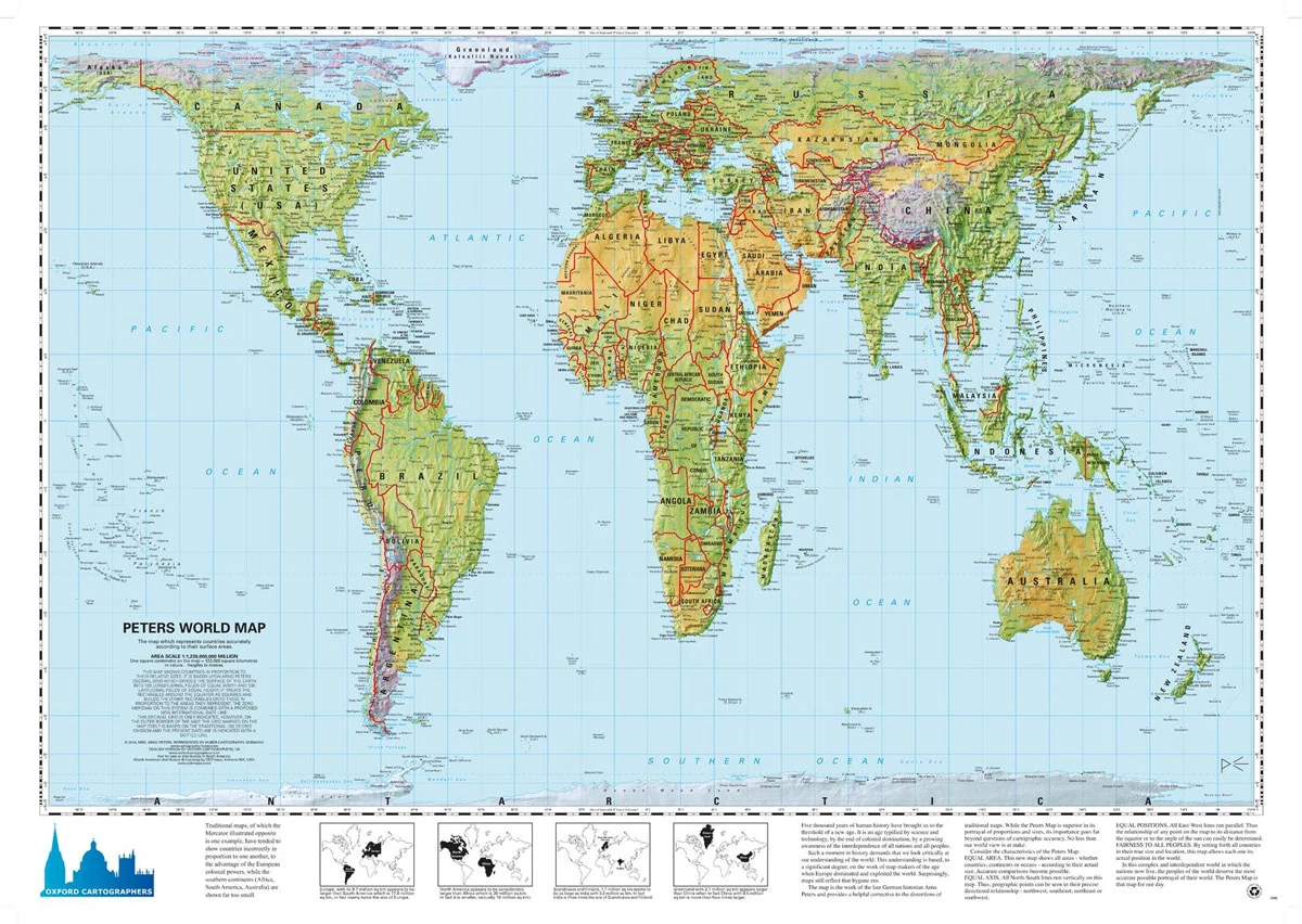
The Organization of Cartographers for Social Equality was a group of map-makers who favored the adoption of an inverted Peters Projection map as mandatory for all education within the United States. They felt strongly that traditional Mercator maps gave undue focus on the nations and peoples of the Northern Hemisphere.
https://westwing.fandom.com/wiki/Organization_of_Cartographers_for_Social_Equality
Gotta admit, the old map looked more aesthetic.
Thankfully that isn’t the new UN map. This one is.

Dumbass United Stat…
Americans are probably the dumbest people on the planet.
Source: been here my whole life
NOT TRUE. there’s those stupid short folk on the falklands with the webbed feet and the orange noses, what smell awful and like bad fish who dress formal everywhere. they’re pretty silly
There’s plenty dumber, trust me, but Americans are proudest of their dumbness